|
|
||||||||||||
|
3rd
Grade Local Rocks Program (Piedmont and Blue Ridge rocks) |
On this page you can
download the graphics, lesson plans, and Google Earth files developed by Roadside
Geology of Georgia |
|||||||||||
|
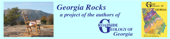
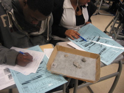
In the Local Rocks and
Minerals program, third graders are guided through simple
observations about the five most common stones (rocks or minerals) in their
area. In DeKalb County, as in much of the Blue Ridge and Piedmont, these are granite, gneiss, schist,
amphibolite, and vein
quartz. FSC instructor Nathaniel Haeck co-developed this activity. |
|
|||||||||||
|
Students work in teams of three or four to place
each sample at its labeled place on a mat, and then each student is
self-tested. Click here to download the Blue Ridge/Piedmont set of activities
as a 2.2 MB zip file. |
||||||||||||
|
|
|
|||||||||||
|
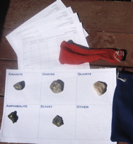
The Investigating
Rocks program for middle
school presents eight rocks and how their textures tell the stories of their
origins. Four are igneous rocks: scoria, obsidian, volcanic
breccia, and granite. Three
sedimentary rocks, conglomerate, sandstone, and limestone,
and a metamorphic rock, slate, round out
the set. The rocks are placed on a sheet of pictures,
showing the typical environment in which each rock begins. The students also work with an identification
flow chart specific to the eight rocks, and a "rock textures and what
they tell" chart to match up specific textures with rock histories. Download
the activities as a 2.9 MB zip file. |
|
|||||||||||
|
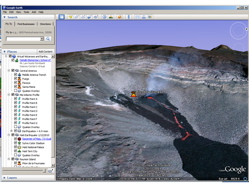
Virtual Voicanoes and Earthquakes is a program for use in a computer lab in which
each student has access to a computer loaded with Google EarthTM.
A Google Earth .KMZ file contains placemarks
that guide students to volcanoes, active faults, and undersea features, as
well as path lines that let them generate topographic
profiles across plate boundaries, and overlay
maps showing 3D earthquake
patterns. A simple scavenger hunt exercise is also included in the 1.1 MB zip file. |
|
|||||||||||
|
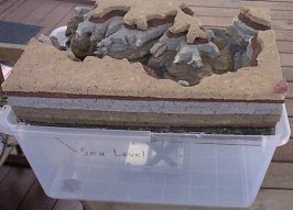
Timecraft at the Grand Canyon is a lesson on geologic time based on a foam rubber model of the Grand Canyon. Involve
your students in building the model – actually two models, one
consisting of layers put down one at a time representing the long history of
deposition, and a second model of the same layers cut to demonstrate stages
in eroding the canyon. Once the model is built, you can teach with it for
years using a script that imagines
students traveling through the Earth’s 4.6 billion years in a “timecraft”
(like a spacecraft) while geologists in Arizona and Georgia describe the
local geologic evidence. A follow-up activity is a card
game with rules similar to gin rummy, the “Grand Time Game,” which
teaches about the kinds of evidence that fossils provide. The model
instructions, card game, and script are found here
on Fernbank Science Center’s web site. |
|
|||||||||||
|
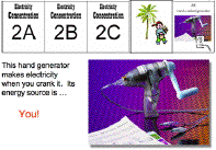
Electricity
from the Sun is a lesson about the Sun as the ultimate source of most of the electricity we
use, whether it be generated by burning fossil fuels such as coal or by
harnessing renewable sources such as wind and water. You will need two hand
cranked generators (such as GeneconTM), a small photovoltaic cell,
and a VernierTM voltage probe with LoggerLiteTM
software to do the lesson as designed. A PowerPoint slide
show and cards for playing “Electricity
Concentration” are included in the 25.7 MB zip
file. FSC instructor Mary Breen co-developed this activity. |
|
|||||||||||
|
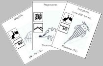
Fossils
and Evolution was developed to give students hands-on experience with fossils.
It was built around a collection of trays of five fossils, each tray
representing one of the thirteen geologic periods from Cambrian time to the
present. Students look up the fossils in a catalog of pictures of the fossils
making up the collection. They record information such as name and range of
the fossil and its major group, then they read information about the major
group off a “Tree of Life” chart. The chart,
developed for Fossils and Evolution, shows the branching of major groups and their abundance in the
fossil record, along with the geologic time scale. It is part of a 7.7 MB zip file. |
|
|||||||||||
|
|
||||||||||||
|
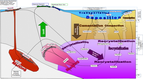
In the Rock
Transformations lesson for high school Earth Systems students, the student works with 17 different
rocks and learns the transformations that generated each rock. An 11X17 color mat diagrams the rock transformations. These
include magma–basalt-amphibolite, magma-peridotite-soapstone, magma-granite/pegmatite,
sand-sandstone-quartzite,
sand+clay-graywacke-metagraywacke-gneiss,
clay-shale-slate-phyllite-schist,
and carbonate skeletons-limestone-marble. Note that the end products are rocks
commonly found in the Georgia Piedmont and Blue Ridge. As students recognize the
rocks they lay them out on the mat and then memorize the mat layout and rock
identification as one activity. The mat and lesson plan are in this 741 KB zip file. |
||||||||||||