|
|
|||||||
|
Most of
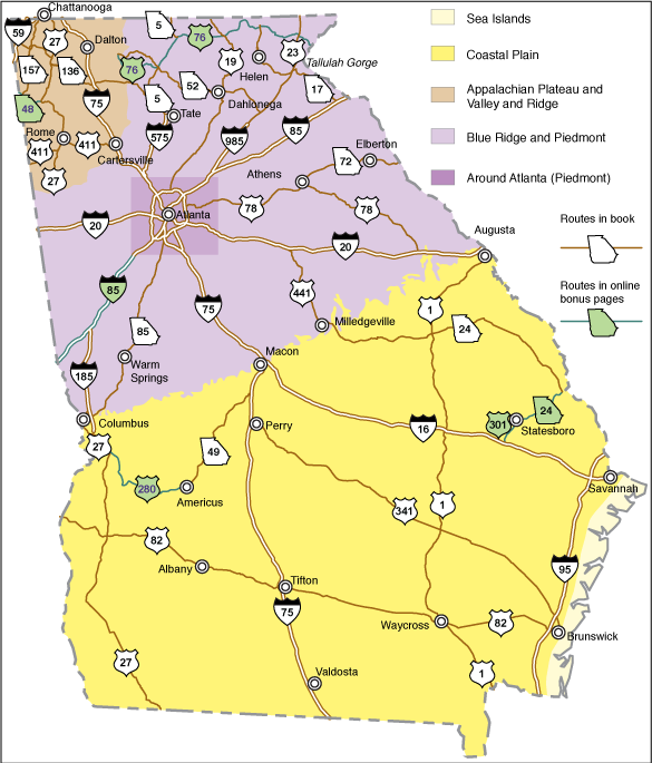
the road guides in Roadside Geology of Georgia contain individual geologic maps,
which are simplified versions of those in the geologic literature, tagged
with the locations mentioned in the text. This online section complements the
book’s maps through access to Google EarthTM Georgia Rocks content. Google Earth is
software you can download that allows flying
through the landscape in 3D. Once you have Google Earth loaded, try this
overview tour including
Roadside Geology page references for many of Georgia's favorite destinations. Or visit the
locations in the
overview tour using Google Maps - no installation required. Here are
the routes that appear in the book, and in
green, those that are being published on
this web site.
This Georgia Rocks added content consists of the following: ·
placemarks
(tagged locations that become “word balloons” when clicked, usually with
narrative and pictures) ·
paths
(lines that mark faults and other geologic features, as well as Roadside
Geology routes) ·
polygons
(transparent colored areas, depicting geologic units as simplified from a digital
version of the 1976 state geologic map), and ·
overlays
(versions of some of the geologic maps in the book, as simplified from the
literature). The "Earth App" links
are versions best for the mobile Google Earth App - the difference being the placement
of the map legend that floats over the map. You will appreciate being able to use the maps in the field,
especially the ability to show your current location as a blue dot, but be patient: zooming around the
landscape is slower on 3G than when using a wi-fi connection.
All
Georgia (5.5
MB download; not recommended for mobile devices) Appalachian Plateaus/Valley and
Ridge
The Google Earth versions include a "pull-up" version of the cross section from p. 125 of the book. The pull-up section and the
floating map legend were made with the help of Google Earth tools
developed and freely shared by Steven Whitmeyer of James Madison University. Terranes are an important concept in this
region. A terrane is an area
that was widely separated from other terranes for part of its history, and
was assembled with the others by the movements of plate tectonics. All the terrane
boundaries in Georgia are also major faults. Identifying terranes is a work in progress, and there are
minor differences between different authors’ versions. We have followed the
version by Hatcher, Bream, and Merschat (2007). A Google Earth version of the book's terrane map (p. 184) together with a version of the p. 186 cross section "pulled up" along the line of section, can be downloaded here.
In addition, a reconstruction of terrane original positions to accompany the book's discussion on pp. 181-185
is available here. Moving terrane polygons on Google Earth was done by
moving back and forth between .kml and Excel formats, which might be made simpler today by tools on the
EarthPoint website. A
difference between maps in the book and the web site is that in the book,
each terrane has a different color scheme. In the online geologic maps, there is a
single color scheme of rock types for the Blue Ridge and Piedmont, and heavy
red lines designate the terrane boundaries. Blue
Ridge/ Piedmont (1976 state map geology) – Earth / Earth App Including
geology from other sources as optional overlays – Earth Around
Atlanta (geology after Higgins and Crawford, 2006) – Earth/ Earth App Lastly, there is a special Google Earth
file on Tallulah Gorge, with Google Earth topographic profiles across it and 4 other gorges for comparison,
as well as its relation to the rivers that drain the northeast corner of Georgia. |
|||||||
|
|
|||||||